Showing posts with label HiRISE. Show all posts

Thursday, February 23, 2012

With recent news of the Moon being 'geologically active' it seems the Red Planet may be too

Mars rocks indicate relatively recent quakes, volcanism, on Red Planet
(PhysOrg.com)
Feb 20, 2012

(PhysOrg.com) -- Images of a martian landscape offer evidence that the Red Planet’s surface not only can shake like the surface of Earth, but has done so relatively recently. If marsquakes do indeed take place, said the scientists who analyzed the high-resolution images, our nearest planetary neighbor may still have active volcanism, which could help create conditions for liquid water.
Mars rocks indicate relatively recent quakes, volcanism, on Red Planet
Scientists have found evidence of relatively recent quakes on the surface of Mars by studying boulders that fell off cliffs, leaving tracks behind.(HiRISE image), credit: AGU; NASA; PhysOrg  [Larger Image]

With High Resolution Imaging Science Experiment (HiRISE) imagery, the research team examined boulders along a fault system known as Cerberus Fossae, which cuts across a very young (few million years old) lava surface on Mars. By analyzing boulders that toppled from a martian cliff, some of which left trails in the coarse-grained soils, and comparing the patterns of dislodged rocks to such patterns caused by quakes on Earth, the scientists determined the rocks fell because of seismic activity. The martian patterns were not consistent with how boulders would scatter if they were deposited as ice melted, another means by which rocks are dispersed on Mars.

Gerald Roberts, an earthquake geologist with Birkbeck, an institution of the University of London, who led the study, said that the images of Mars included boulders that ranged from two to 20 meters (6.5 to 65 feet) in diameter, which had fallen in avalanches from cliffs. The size and number of boulders decreased over a radius of 100 kilometers (62 miles) centered at a point along the Cerberus Fossae faults.

“This is consistent with the hypothesis that boulders had been mobilized by ground-shaking, and that the severity of the ground-shaking decreased away from the epicenters of marsquakes,” Roberts said.

The study, by Roberts and his colleagues, will be published Thursday in the Journal of Geophysical Research-Planets, a publication of the American Geophysical Union (AGU).

The team compared the pattern of boulder falls, and faulting of the martian surface, with those seen after a 2009 earthquake near L’Aquila, in central Italy. In that event, boulder falls occurred up to approximately 50 km (31 miles) from the epicenter. Because the area of displaced boulders in the marsscape stretched across an area approximately 200 km124-miles) long, the quakes were likely to have had a magnitude greater than 7, the researchers estimated.
By looking at the tracks that the falling boulders had left on the dust-covered martian surface, the team determined that the marsquakes were relatively recent – and certainly within the last few percent of the planet’s history – because martian winds had not yet erased the boulder tracks. Trails on Mars can quickly disappear – for instance, tracks left by NASA robotic rovers are erased within a few years by martian winds, whereas other, sheltered tracks stick around longer. It is possible, the scientists concluded, that large-magnitude quake activity is still occurring on Mars.

The existence of marsquakes could be significant in the ongoing search for life on Mars, the researchers stated. If the faults along the Cerberus Fossae region are active, and the quakes are driven by movements of magma related to the nearby volcano, Elysium Mons, the energy provided in the form of heat from the volcanic activity under the surface of Mars could be able to melt ice. The resulting liquid water, they noted, could provide habitats friendly to life.

More information: "Possible evidence of palaeomarsquakes from fallen boulder populations, Cerberus Fossae, Mars" Journal of Geophysical Research-Planets.

American Geophysical Union: News and Web

Friday, February 3, 2012

View all HiRISE images from the Mars Reconnaissance Orbiter (MRO) on the Univ. of Arizona mission page

        HiRISE High Resolution Imaging Science Experiment
                   M A R S  R E C O N N A I S S A N C E  O R B I T E R
                                                                                       NASA/JPL : THE UNIVERSITY OF ARIZONA

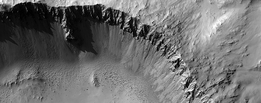
Another Well-Preserved Impact Crater
Image: NASA/JPL/University of Arizona 


"Explore Mars, one giant image at a time," by visiting HiRISE`s University of Arizona mission page by clicking here for a full complete catalog of in-depth imagery, video and related content.

Thursday, February 2, 2012

More stunning craters on Mars by MRO`s HiRISE

MRO HiClip: "Rêve Martien"
Uploaded by djxatlanta on Feb 1, 2012; credit: NASA/JPL/University of Arizona

The Floor of Toro Crater; Crater with Gullies on a Central Structure; Active Erosion in Pasteur Crater; Another Well-Preserved Impact Crater.

credit: NASA/JPL/University of Arizona
source: http://hirise.lpl.arizona.edu/media/


Copyright Disclaimer [Rubaiat`s Blog]:
The use of incidental copyrighted material is covered under 'Fair Use' (Copyright Act, 1976) Title 17 U.S.C Section 107, with particular emphasis on such use for educational and non-profit purposes. Under Sec. 107 of the Copyright Act (1976), allowance is made for 'Fair Use' for purposes such as criticism, comment, news reporting, teaching, scholarship, and research. Fair Use is a use permitted by copyright statute that might otherwise be infringing. Non-profit, educational or personal use tips the balance in favor of Fair Use (Moe, AllSeeingEye). If you wish to use copyrighted material from this site for purposes of your own that go beyond 'Fair Use', you must obtain permission from the copyright owner.
Digital Millennium Copyright Act-
In Aug 2008, U.S. District Judge Jeremy Fogel of San Jose, California, ruled that copyright holders cannot order a deletion of an online file without determining whether that posting reflected "fair use" of the copyrighted material.
[View the blog`s full Fair Use Copyright Disclaimer at the end of the homepage]

MRO captures stunning 'fresh' impact craters and their gullies on Mars

MRO HiClip: "Impact"
Uploaded by djxatlanta on Jan 22, 2012; credit: NASA/JPL/University of Arizona

Colorful gullies in a fresh impact crater, gullies in Bamberg Crater, tongue-shaped flow below a scarp in Phlegra Montes and the floor of Beer Crater, Mars Reconnaissance Orbiter.

credit: NASA/JPL/University of Arizona
source: http://hirise.lpl.arizona.edu/media/

Copyright Disclaimer [Rubaiat`s Blog]:
The use of incidental copyrighted material is covered under 'Fair Use' (Copyright Act, 1976) Title 17 U.S.C Section 107, with particular emphasis on such use for educational and non-profit purposes. Under Sec. 107 of the Copyright Act (1976), allowance is made for 'Fair Use' for purposes such as criticism, comment, news reporting, teaching, scholarship, and research. Fair Use is a use permitted by copyright statute that might otherwise be infringing. Non-profit, educational or personal use tips the balance in favor of Fair Use (Moe, AllSeeingEye). If you wish to use copyrighted material from this site for purposes of your own that go beyond 'Fair Use', you must obtain permission from the copyright owner.

Digital Millennium Copyright Act-
In Aug 2008, U.S. District Judge Jeremy Fogel of San Jose, California, ruled that copyright holders cannot order a deletion of an online file without determining whether that posting reflected "fair use" of the copyrighted material.
[View the blog`s full Fair Use Copyright Disclaimer at the end of the homepage]

Friday, January 27, 2012

MRO captures spectacular sand dunes on Mars

The image below shows dunes and sand ripples of various shapes and sizes inside an impact crater in the Noachis Terra region of southern Mars. It was taken by the High Resolution Imaging Science Experiment (HiRISE) camera on NASA's Mars Reconnaissance Orbiter (MRO).

This enhanced-color image shows sand dunes trapped in an impact crater in Noachis Terra, Mars. Image credit: (Credit: NASA/JPL-Caltech/Univ. of Arizona)

More than 20,600 images taken by HiRISE are available for viewing on the instrument team's website: http://hirise.lpl.arizona.edu. Each observation by this telescopic camera covers several square miles, or square kilometers, and can reveal features as small as a desk.

HiRISE is operated by the University of Arizona, Tucson. The instrument was built by Ball Aerospace & Technologies Corp., Boulder, Colo. The Mars Reconnaissance Orbiter project is managed by the Jet Propulsion Laboratory, Pasadena, Calif., for NASA's Science Mission Directorate, Washington. JPL is a division of the California Institute of Technology, also in Pasadena. Lockheed Martin Space Systems, Denver, built the spacecraft.

For more information about the Mars Reconnaissance Orbiter, see www.nasa.gov/mro.